


New
New
Using grid references to identify land use
I can use four figure grid references to identify different examples of land use in my local area on a 1:25000 map.


Lesson 5 of 6
New
New
- Year 3
Using grid references to identify land use
I can use four figure grid references to identify different examples of land use in my local area on a 1:25000 map.
Lesson details
Key learning points
- The map of Great Britain is covered by grid squares measuring 100 kilometres across
- OS maps have a series of grid lines that help you to pinpoint an exact location anywhere on the map
- Vertical lines are called 'eastings' as they increase in value as you travel east on the map
- The horizontal lines are called 'northings' as they increase in value as you travel north on the map
Keywords
Vertical - Something vertical stands upright or points upwards from the ground.
Horizontal - Something horizontal is parallel to the ground.
Pasture - Pasture is land, with grass and other low plants, suitable for livestock to graze on.
Agriculture - Agriculture is the science and practice of cultivating soil and farming.
Common misconception
Pupils may be aware of the National Grid as the network which is used to supply electricity.
Explain that the National Grid for OS maps is not (quite) the same thing.
Although there are not many clues on maps for agriculture or bogs, as it is their local area, children will have some experience of the land type from personal experience. They could also use google street view/aerial images to identify land use.

Teacher tip

Licence
This content is © Oak National Academy Limited (2026), licensed on Open Government Licence version 3.0 except where otherwise stated. See Oak's terms & conditions (Collection 2).
Lesson video
Loading...
Prior knowledge starter quiz
6 Questions
Q1.What type of land use is this?
What type of land use is this?

artificial surfaces
moorland and heathland
Q2.Which land use type can be seen in this image?
Which land use type can be seen in this image?
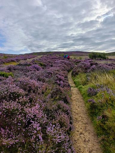
pasture
artificial surfaces
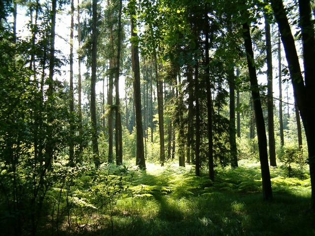
Q3.This image shows land use.
This image shows land use.
Q4.Match the land use type with their definition.
Match the land use type with their definition.

Q5.What is the main type of land use in the UK?
What is the main type of land use in the UK?
artificial surfaces
woodland
peat bogs
Q6.How much of the land in the UK is used for agriculture?
How much of the land in the UK is used for agriculture?
one quarter
all of the land
Q3 Forest near Vřesina, Jiri Brozovsky, 2013, Licensed under CC-BY 2.0
Assessment exit quiz
6 Questions
Q1.The horizontal blues lines on an Ordnance Survey map are called ...
The horizontal blues lines on an Ordnance Survey map are called ...
Q2.The vertical blue lines on an Ordnance Survey map are called ...
The vertical blue lines on an Ordnance Survey map are called ...
Q3.Order these instructions to find a four digit grid reference.
Order these instructions to find a four digit grid reference.
Q4.What is the grid reference of St Mary's Island and lighthouse?
What is the grid reference of St Mary's Island and lighthouse?
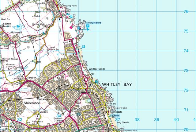
3475
3576
Q5.What is the grid reference of the caravan park?
What is the grid reference of the caravan park?
3375
3275
Q6.What is the main land use of grid square 3473?
What is the main land use of grid square 3473?
pasture
woodland
moorland and heathland
Q4 © Crown copyright and database rights “2025” Ordnance Survey (100025252) Q5 © Crown copyright and database rights “2025” Ordnance Survey (100025252) Q6 © Crown copyright and database rights “2025” Ordnance Survey (100025252)
